Monday, June 29, 2020

Hike: Pt. Mugu/La Jolla Loop / June 2020

Hike: Pt. Mugu/La Jolla Loop / June 2020

We did the hike to Pt. Mugu 2 years ago so this time we figured we'd do the trail that heads across the plains into the Chumash valley. Besides the initial 3/4' hike up the steep, rugged and thigh breaking bluff to get to the mountains where you can reach Mugu peak and more, the trail isn't too hard or strenuous. A fairly innocuous hike, fog-shrouded until you to the grass covered plains, and deeper into the mountains.

Length: 6.5 / Elevation gain: 1,200' / Highest Elevation Point: 1,245'.


Monday, June 15, 2020

Road Trip: Grapevine / February 2020

Road Trip: Grapevine / February 2020

A quick little road trip around the Grapevine area - just south of Fort Tejon and the Tejon pass, in the Los Padres mountains.


Road Trip: Palms to Pines Scenic Byway / February 2020

Road Trip: Palms to Pines Scenic Byway / February 2020

This is the scenic route driving from I10 near Morongo up into the San Jacinto wilderness (and the most impressive Mt. San Jacinto - a future epic hike destination) and through, then back down the winding roads leading to Desert Hot Sprints and Palm Springs - hence the Palms to Pines nomer.


Road Trip: Death Valley National Park / February 2020

Road Trip: Death Valley National Park / February 2020

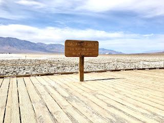
No hike this week (unless you count a beach walk at El Matador) so here's a trip back through time - not too far back, though - to Death Valley back in February. Didn't really do any hikes (although I did a short 'excursion' through some of Gold Canyon - probably about 4 miles, round trip.) This was my fourth trip to Death Valley, and it's as impressive as ever. A great time of the year to visit. This trip? Zabreski Point, Dante's View, Badwater Basin.


Monday, June 8, 2020

Hike: Mt. Baldy / June 2020

Hike: Mt. Baldy / June 2020

What did we do over the weekend? Mt. Baldy, the highest mountain the San Gabriel mountain range, that's what. Unfortunately, we didn't summit. But we came close. This was due to circumstances out of our control (some tired feet, exhausted bodies, and some almost gale force, bone-chilling winds).

I did summit Mt. Baldy back in November of 2019, so I mostly onboard as moral support and assistance. While I wasn't tremendously saddened by not making the summit (only a mere half mile away, but sometimes that last half mile seems so much further away!) it would've been nice to make the successful climb a second time. I was promised there would be another attempt at some future date.

Mt. Baldy is no hike in the park, haha. In fact, it's a pretty strenuous hike by almost any measure. Plus we ascended and descending via the Baldy Bowl, the harder way to make the adventure. It's an almost unrelenting 4,100'+ of elevation gain with multiple knee-busting switchbacks and some fairly steep butt burning and often, slippery, climbs. The fact that you are moving from roughly 6,000' to 10,100' adds to the lure, and the exhaustion.

Length: 10 miles / Elevation gain: 4,100' / Highest Elevation Point: 10,100'.


Monday, June 1, 2020

Hike: Orchard Camp/Manzanita Peak/Mt Wilson / May 2020

Hike: Orchard Camp/Manzanita Peak/Mt Wilson / May 2020

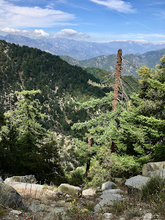
What started out as a repeat hike in the Pasadena area to Orchard Camp (roughly 3 miles round trip) which was then extended to Manzanita Ridge (roughly 5 miles) and finally, extended again to the foot of Mt. Wilson (7 miles round trip), turned into a race against time - with dusk and sunset arriving around 8:30, and exhaustion setting in on... some people. :)

We started the hike around 10:30 and finished around 8 - almost 9.5 hours - though indecisiveness and a certain non-challance revealed themselves early on, a certain 'method hiking' approach took over at the point our destination goal posts kept getting pushed forward, lol.

Don't blame me, but this half day trip turned into a fun, full day hike as well as a very tiring, challenging, and rewarding sojourn. Our feet can bear witness to that. Unfortunately, a plethora of swarms of flies and mosquitoes on this trail robbed it of some of the enjoyment, but that didn't deter us from finishing (and running into some interesting challenges involving small medical issues brought on by ill-fitting footwear, haha!)

Length: 7 miles / Elevation gain: 4,400' / Highest Elevation Point: 5,408'.